
Projects
Coppermine
Project
Overview
The Coppermine Project is located in the Kitikmeot region of Nunavut and consists of 102 exploration licences and one exclusive exploration right executed with Nunavut Tunngavik Incorporated (NTI), covering 1,665 km2 in total, serving to position Somerset as the largest landholder in the Coppermine region. Importantly, the Project covers a significant portion of the Copper Creek Formation which is known to host high-grade copper mineralisation.
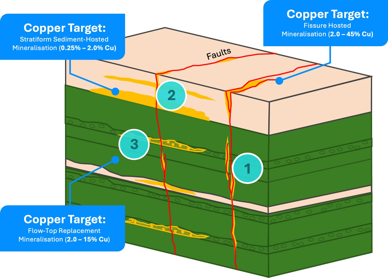
The Project presents a regional-scale copper-silver exploration opportunity within the Copper Creek basalts, which hosts high-grade structurally controlled sulphide and native copper mineralisation in brecciated sub-vertical fault zones. Copper mineralisation in the Project area principally occurs in three styles: fissure-hosted (~2.0 – 45% Cu), sediment-hosted (~0.25 – 2.0% Cu), and basalt flow top replacement (~2.0 – 15% Cu).1 The region’s geology and mineralisation is analogous to the Keweenaw Peninsula copper deposits in Michigan, which host high-grade native Cu in continental flood basalts and sediments, in basalt flow tops and fault zones. A comparable example in Australia exemplifying the structural component is the epigenetic Cu-Au mineralisation seen in the Mt Isa region, such as the Rocklands deposit containing high-grade copper mineralisation in sub-vertical lodes and fissures.
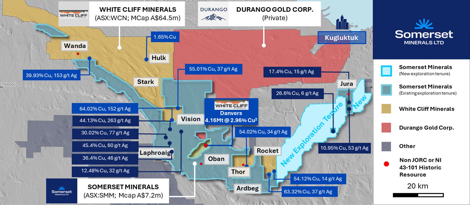
While the entire land package remains highly prospective, the region has seen very little exploration activity since the 1960s, leveraging off these historical results and those more recently from Kaizen Discovery (later acquired by Durango Gold Corp.) the company has identified four high priority targets, namely:
- Coronation Prospect (Oban District): Located immediately to the south of White Cliff’s Danvers historic resource of 4.1Mt @ 2.96% Cu,2 the Oban District hosts the Coronation prospect which contains a historic resource which remains open at depth and along strike. Historical drilling, surface sampling and geophysics (resistivity and induced polarisation) serve to provide drill ready targets.
- Jura District: Located in the eastern part of the project area, Jura consists of a 7.0km high-grade mineralised trend and includes a historical drill defined resource to the north, with the broader 7km trend supported by high-grade rock chips including 17.4% Cu & 15g/t Ag.3
- Laphroaig District: Immediately along strike from White Cliff Minerals’ Vision District (Don & Pat prospects) which recently returned high-grade rock chip samples up to 64.02% Cu & 152g/t Ag.4 The continuity of high-grade mineralisation at Somerset’s Laphroaig District is supported by a number of high-grade rock chip samples including 45.4% Cu & 60.0 g/t Ag.5
- Ardbeg District: Located immediately south of White Cliff Minerals’ Thor and Rocket Districts (Halo and Cu-Tar targets) which recently returned high-grade rock chip samples up to 54.02% Cu & 34g/t Ag.6 Somerset’s dominant land position surrounding the Thor and Rocket Districts is supported by a number of historic drill holes and surface sampling.
Location
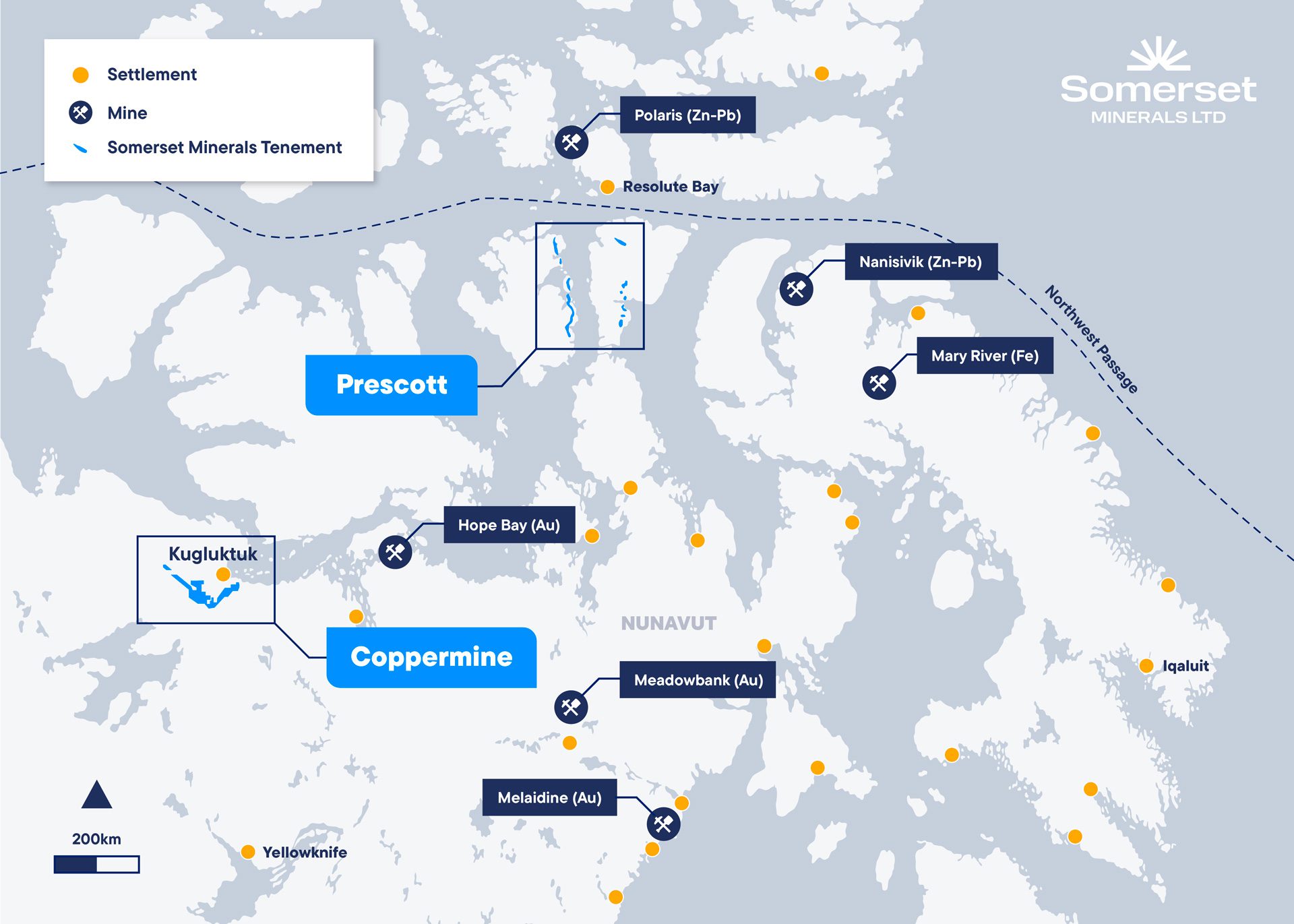
The Coppermine Project is located in the Kitikmeot region of Nunavut, Canada, near the Coronation Gulf coastline and approximately 537 kilometres northwest of Yellowknife. Kugluktuk is the closest community to the Project area, a hamlet with about 1,500 residents, situated near the border of the Northwest Territories. Kugluktuk serves as a key logistical hub for the project, accessible by both air and sea, with daily commercial flights connecting to Yellowknife. The Company initially plans to base its logistics operations in Kugluktuk, positioned around 26 kilometres from the project site.
The Hope Lake airstrip, a well-maintained 800-metre runway built in the 1960s, facilitates supply transport to the Coppermine Project area. Lakes in the region provide additional fixed-wing access, while snowmobiles, tundra quads, and helicopters support year-round access. Seasonal factors such as fog and tundra thaw in May occasionally restrict access. Historical two-track roads connect several of the mineral showings to the airstrip and lakes, ensuring practical exploration and transportation throughout most of the year.
Nunavut is well-versed in large-scale mining and exploration activities, hosting operations such as Agnico Eagle’s Meadowbank Complex and the separate Meliadine Mine, as well as the Mary River iron ore operations. Historically, the region housed significant zinc-lead producers like the Nanisivik and Polaris mines. Nearby, there are a number of near-term developers including MMG’s High Lake and Izok projects (Zn-Cu), as well as Agnico Eagle’s Hope Bay project (Au).7

Both projects located
adjacent to coast

Access to designated sealift route

Historical mining district with established logistics network and supportive local government

Year-round mining, with reliable shipping window
Regional Geology & Copper Mineralisation
Regional Geology
The Coppermine River Project lies within the Great Bear magmatic province, northwest of the Slave Craton, and can be subdivided into Meso-Neoproterozoic stratigraphic units. The area overlays the Wopmay Orogen with basal units from the Paleoproterozoic Hornby Bay Group, comprising fault-bound siliciclastic rocks and fluvial deposits. These are succeeded by the Dismal Lakes Group, with siliciclastic, carbonate, and evaporite sequences deposited on a fluvial-marine shelf during the mid-Mesoproterozoic.
The mid-Mesoproterozoic saw significant igneous activity linked to a mantle plume, including the Muskox Intrusion (1270 Ma) and Mackenzie Dyke Swarm. Shortly after (1267 Ma), the Coppermine River Group formed, featuring tholeiitic basalts of the Copper Creek Formation and immature sediments of the overlying Husky Creek Formation. Basalt flows, up to 300 m thick, are traceable over 16 km and display evidence of crustal contamination and fractionation trends. With an estimated magma volume of 650,000 km³, the Coppermine River basalts represent one of the world’s largest flood basalt regimes, comparable to the Keweenaw Peninsula flood basalts (USA).
Overlying the Coppermine River Group is the Rae Group, deposited during the Neoproterozoic, comprising sandstones, shales, and carbonates. These rocks were later intruded by Coronation gabbro sills, associated with the Franklin Igneous Event (723 Ma), marking the breakup of Rodinia. This event produced an extensive dyke suite radiating from a focal point on Victoria Island, highlighting the region’s dynamic geological evolution.
Property Geology
The Coppermine River Group is composed of two formations: the basal Copper Creek Formation, and the overlying Husky Creek Formation. The Copper Creek Formation is 2,000‐3,500 m thick, and is composed of a series of over 150 different flood basalt flows that exhibit massive bases with amygdaloidal flow tops. The individual flows range in thickness from 3-90 m, averaging between 8 and 23 meters. The lower flows display submarine emplacement textures such as basaltic pillows. The upper sequence was emergent and subaerial, displaying ‘a‘a and ropey textured tops with increased iron oxidation and vesiculation with columnar jointing.
Basalts in the Copper Creek Formation contain fine crystals of plagioclase and augite, with a concentration of strongly altered olivine and orthopyroxene phenocrysts lower in the package, and plagioclase concentrations increasing in the upper stratigraphy. The basalts are tholeiitic and exhibit a notable decrease magnesium up‐section, suggesting ongoing fractionation in its source. Native copper is most enriched in the upper third of the formation where it occurs as an accessory mineral, commonly infilling vesicles and within brecciated flow-tops.
The Husky Creek Formation, the upper formation in the Coppermine River Group, is approximately 1,200 m thick and includes an abundance of ‘red‐bed’ (oxidized, iron‐rich) sandstones with minor intercalated basalt flows. A decrease in plagioclase and Fe‐Ti oxides in the Husky Creek basalts illustrate that the Husky Creek erupted from a more evolved magma.
Mineralisation Model
Copper mineralisation in the project area occurs in three main styles: fissure-hosted, sedimentary-hosted, and basalt flow top replacement. Each exhibits unique characteristics and economic potential:
- Fissure-Hosted Mineralisation: This style, primarily in Copper Creek Formation basalts, is the highest-grade and most continuous. It is structurally controlled, occurring in fissures, breccias, shear zones, and faults, with copper occurring as chalcocite, bornite, and minor chalcopyrite. Native copper and silver are occasionally present. Quartz-carbonate veins and breccias often display extensional textures, and mineralised zones can be up to 70 m thick. Alteration minerals include chlorite, epidote, and carbonate in amygdales, with pink K-feldspar a common alteration product. This style is economically significant, resembling deposits like the Cliff Mine (Keweenaw Peninsula, Michigan) and Rocklands deposit at Mt. Isa (Queensland, Australia).
- Sedimentary-Hosted Mineralisation: Found in Husky Creek and Rae Group sediments, this style involves lower-grade, stratiform copper disseminated in permeable sedimentary units. While grades are lower, the potential for higher tonnage exists. Notable drilling results include intercepts such as 29 m at 0.57% Cu, with higher-grade intervals (e.g., 1 m at 3.04% Cu).8 The basal Rae Group and Husky Creek sediments are prospective for this style, with mineralised zones extending over several kilometres.
- Basalt Flow Top Replacement Mineralisation: Occurring as native copper and chalcocite in amygdales, vesicles, and brecciated zones at basalt flow tops, this style yields localised high grades with potential for high tonnage across lateraly extensive zones. This style is interpreted to be analogous to Keweenaw Peninsula copper occurrences.
Footnotes
- Refer to E.D Kindle, 1972, Classification and Description of Copper Deposits, Coppermine River Area, District of Mackenzie ↩︎
- Refer to ASX:WCN 26/11/2024. There is no certainty that further work by the Company will lead to achieving the same size, shape, grade, or form of the comparison resource or project. The Company’s project is in a different stage of development and further exploration needs to be undertaken to further prove or disprove any comparison. ↩︎
- Refer to ASX:WCN, 29/10/2024 – MULTIPLE CONDUCTIVE ANOMALIES IDENTIFIED AT HULK ↩︎
- Refer to ASX:WCN, 29/10/2024 – MULTIPLE CONDUCTIVE ANOMALIES IDENTIFIED AT HULK ↩︎
- Refer to ASX:SMM 10/12/2024 ↩︎
- Refer to ASX:SMM dated 10/12/2024 – Acquisition of High-grade Copper Project Adjacent to ASX:WCN ↩︎
- There is no certainty that further work by the Company will lead to achieving the same size, shape, grade, or form of the comparison resource or project. The Company’s project is in a different stage of development and further exploration needs to be undertaken to further prove or disprove any comparison. ↩︎
- 02/09/2015. Kaizen Discovery Announces Drilling Results From 2015 Exploration Program at the Coppermine Project in Nunavut, Canada. Drillhole CP15_DD009. ↩︎